Good Satellite Imaging Sites

Skunk Baxter

Well-Known Member
OK. So I just woke up a few minutes ago, checked the calendar, and noticed it's, like, the 21st Century. Don't know how that happened without my noticing, but there it is. And it occurred to me that maybe I ought to ditch the horse and buggy and start using some more modern technology. Like, for instance, satellite imaging.

Reason being, I scouted a terrific new grow area a couple of weekends ago, and I'm very excited about it. It's incredibly rugged, wild, and remote - feels like I'm wandering around in some frozen backwater of the Amazon or something - and seems to be exactly what I need for the large grow I have planned this season. Several square miles of utter wilderness.

But the trouble is, it's so thick and so dense, when i was slogging around in it I had a hard time getting a sense of what it's like on a macro scale. It's too thick to see very far, and I was constantly getting turned around while trying to fight my way through and around thick underbrush. I'd like to see what it looks like from above, to confirm that I scouted it accurately. So - how do these satellite sites work? Can anyone recommend a couple of good ones?
 

Skunk Baxter

Well-Known Member
Forgive me for digging this old thread out of the grave, but I never got around to thanking the people who gave me that excellent advice about Google Earth. It was a huge help! I used it to check out some territory adjacent to my favorite growing area, and I was amazed at what I found. Tens of square miles of perfect growing country, that I never would have found if the satellite images hadn't told me it was there.

Thanks, guys. I owe you a debt of gratitude. Here are a few pictures of what you helped me find. Mile after mile of impenetrable swamp, an almost infinite number of tiny islands (some only a few square yards) laced together with streams just deep enough for a canoe. Perfect growing country, all thanks to Google Earth.
 

Attachments

4cyl5spd

Well-Known Member
nice work skunk, looks like a good site! not sure where you live but I found this site useful, very detailed maps showing elevations, roads, some trails, and names of lakes. maybe there's one similar for the US:

The Atlas of Canada - Toporama – Topographic Maps

once you learn some of the google earth features (image overlay and drawing trails) you can set some of these topo maps onto google earth. these are helpful in areas that show very little detail, which are the best spots, IMO.


Skunk Baxter

Well-Known Member
Wow, are those pictures recent? Where the heck do you live. It was 75 today in NC:hump:
I'm in the Central United States, somewhat south of your latitude actually. I took the pictures last month, when you could still walk across the waterways. Now the ice is mostly out, and next week it will be canoe only until late December.
 

Skunk Baxter

Well-Known Member
nice work skunk, looks like a good site! not sure where you live but I found this site useful, very detailed maps showing elevations, roads, some trails, and names of lakes. maybe there's one similar for the US:

The Atlas of Canada - Toporama – Topographic Maps

once you learn some of the google earth features (image overlay and drawing trails) you can set some of these topo maps onto google earth. these are helpful in areas that show very little detail, which are the best spots, IMO.
Oh, that looks like a terrific tool! I don't know if they make one for the States, but if they do I'm going to find it and apply it. Thanks!

And yeah, you're right. It is a terrific site. The beauty of it is not simply that it's so remote, but that it's just utterly enormous. You can stand in the middle of it and see nothing but wasteland all the way to the horizon in almost every direction. It's a floodplain at the confluence of two major rivers, and I challenge anyone to find 30 plants scattered at random in all those square miles of wilderness. The only problem is getting large amounts of product out, but that's not a bad problem to have, eh?
 

4cyl5spd

Well-Known Member
to most ppl, floodplains are not a very exiting place to explore, pretty bland for anyone to go out of their way to see. most canoers I find wanna go down scenic gulllies, full of waterfalls, mountains and cliffs. this place you got looks like the perfect spot!

the only ppl I'd watch out for are bird watchers or duck hunters, looks like a good bird place. and keep it at a safe height, I'd hate to see your babies get drowned!
 

Skunk Baxter

Well-Known Member
to most ppl, floodplains are not a very exiting place to explore, pretty bland for anyone to go out of their way to see. most canoers I find wanna go down scenic gulllies, full of waterfalls, mountains and cliffs. this place you got looks like the perfect spot!
Exactly! Anybody who's going to go to all the work it takes to get into this place probably needs a pretty damned good reason, and for most people it just isn't an exciting enough place to make it worthwhile. It's a damned tough place to canoe in - lots of low spots and beaver dams that force you to portage or drag your canoe. Most people don't want to bother with all that just to explore a swamp. Add to that the fact that very few people even know it exists (hell, I never would have even had a clue it was there if not for Google Earth), and it's not likely I'll have too many people poking around. Personally, I think it's one of the most beautiful places I've seen in a long time, and I'd go there just for the sake of that, but I'm weird that way and most other people are too lazy to work that hard for beauty.


the only ppl I'd watch out for are bird watchers or duck hunters, looks like a good bird place. and keep it at a safe height, I'd hate to see your babies get drowned!
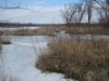
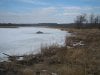
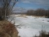
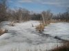
More good advice. Yeah, one of the first things I noticed about it is that there are a lot of high spots - most of the dry land will flood in the spring, when the snow melts, but by late April-early May the high spots will be dry and they'll stay that way all summer. It's, like, about 5 miles wide, so it's too broad an area to flood in a rainstorm. Takes a whole winter's worth of snowmelt to flood the high ground.

I'm not too worried about birdwatchers, for the reasons stated above. I don't think many of them even know it's there, and for those who do, it's too remote for them to get to easily. I'm sure some of them will be poking around the outer edges of the place, but I'll be a mile in from them, and unless they're willing to fight their way in with a canoe, they won't get as far in as I am. Also, this is right next to an area I've planted in for years, so I know how many people come and go. Anyone entering this new area has to pass through the area I've been in for the last few summers, and I don't think I've ever seen a birdwatcher in there.

Duckhunters are a different story, of course. Again, most of them will be in the outer edges, but they'll still be something to keep an eye on in the latter part of the grow. I'll probably have to do my harvesting and hauling out at night.

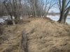
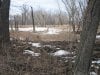
The biggest problem is going to be other growers. I know there are some there. When I scouted it, I found evidence of at least 2, possibly as many as 3. They were cocky because they didn't think anyone would be prowling around back there in the winter time, and they left 5-gallon buckets and other supplies poorly hidden in various places. I made note of where they are, and will plant all my patches at least a mile from any of them. There's plenty of room for me to do that, and frankly I like the idea that I'll be planting in areas that are even harder to reach than theirs.

My evaluation of their thought process (based on the sites they chose and the way they stash their gear) is that they figured this entire area is so remote and so obscure, nobody will ever come near it, so they don't have to worry too much about concealment once they're in there. They plant very close to the streams, in relatively open areas. I'll leave those spots to them, and mostly use harder-to-reach areas farther from the streams. I won't even use the same streams they do for my access, because i don't want to accidentally paddle through an area that may be under surveillance. Again, there's plenty of room in there for me to skirt their areas by as much as a half mile or more on my way in and out. One more reason it pays off big-time to scout your area thoroughly all year round - if I hadn't gone over the place with a fine-tooth comb every weekend for 2 or 3 weeks, I might not have found their gear, and could have planted right in the middle of someone else's spot. All I can do is hope I didn't miss anyone else's area, but that's the risk you take anywhere, and it's probably pretty remote.
 
Top